
Click on the image for a larger version.
Other Repeaters
of the Intermountain
Intertie
Utah Repeaters
|
Scott's Hill, near Brighton, Utah - Elevation
10,000 Feet (3049 Meters) ASL
145.27 (-) 100.0 Hz tone
The location of the Scott's Hill site is a bit hard to describe if you
haven't been there: It is north of Brighton Utah, not too far
away from Guardsman Pass. Most of the equipment on site has
to do with relaying TV signals in to SouthWest Wyoming and extreme
NorthEastern Utah, and there are various other radio services as
well. The coverage of the 145.27 (negative offset, 100.0 Hz
tone) is nearly identical to that of the Hidden
Peak repeater - except that it doesn't cover as well to the
south. It, too, is tied full-time to the Intermountain Intertie.
There is also a UHF repeater on-site (it is not linked to any other system) on 449.525 (131.8 Hz tone) that is also available for all amateurs to use.
For more pictures from Scott's Hill, click here.
Farnsworth Peak, 18 miles SW of Salt Lake City -
Elevation 8950 Feet (2729 Meters) ASL
147.12 (+) 100.0 Hz tone
 |
The Oquirrh (prounounced "Oh-Kerr") mountains are those that bound the
west side of the Salt Lake valley. In the northern half of
the range (approximately even with 50th south) is one of several
broadcast sites in this range - this one owned by one of the local TV
stations.
At this site is installed
several amateur repeaters, including the 147.12 repeater.
Because of its location, it provides coverage all along the Wasatch
Front, from the southern end of Utah county up north to the Idaho
border along Interstate 15. Due to local geography, however,
there are a few "weak" spots in the Weber/Box Elder county area - this
due to blockage from the tower itself as well as a larger transmitter
facility located just north of this site, along the ridgetop.
More recently, the output power of the 147.12 repeater was increased
allowing it to be "heard" a bit better along the Wasatch Front.
The location of this repeater
also allows it to act as a link site to other Intertie repeaters in
southern and central Utah. For several years now, it has been
used to link to Frisco peak (near Milford, Utah) via 70cm.
This path, however, is somewhat difficult as it grazes the Sheeprock
mountains near Vernon, causing the 70cm signals to and from Frisco Peak
to vary somewhat and requiring fairly large antennas and higher power
to maintain a solid link. More recently, with the
installation of the Levan Peak repeater, a superior, alternate link -
through Levan Peak - is possible: Levan Peak, being
line-of-sight to both Frisco Peak and Farnsworth Peak is now used as
the primary relay point into the southern Intertie repeaters, although
the direct link to Frisco is still maintained as a backup.
This repeater is linked to the
Hidden Peak repeater at the top of the Snowbird tram which, in turn, is
the "hub" repeater to many other repeaters and links into Wyoming,
Idaho, and Montana.
For more pictures from Farnsworth, click here.
Levan Peak, - Elevation 8350 Feet (2546 Meters) ASL
145.27 (-) 103.5 Hz tone
 |
For many years, the Intertie had a "dead spot" in the middle of
Utah: While it provided coverage along the Wasatch Front,
southwestern Wyoming and into Idaho as well as into the southwestern
corner of Utah, it didn't cover well in centeral Utah - until recently.
Several years ago, permission
was obtained to place a new intertie repeater on Levan Peak in the
central portion of Utah, but it wasn't until near the end of 2007
before all of the necessary work (mountain of antennas on towers,
running feedline, preparing radios for the site, and making
modifications to other sites to interface with the new site at Levan
Peak) was finally completed.
This repeater re-uses a
frequency pair also used in two other places on the Intertie (Scott's
Hill near Brighton, UT and Mt. Harrison near Burley, ID) but because
the primary coverage areas of these other repeaters are so distant,
interference is unlikely. Nevertheless, Levan Peak's
subaudible tone is 103.5 Hz - a departure from the normal 100.0 Hz tone
used elsewhere on the Intertie. Why was this done?
It was noted that it was possible to use the Levan Peak repeater into
Utah County (where coverage of the 147.12 repeater is much
better) and get some interference from the Scott's Hill
repeater on the same frequency: If the same tone had been
used, a user could have brought up both repeaters at once, possibly
causing problems to those listening on the Intertie.
Levan Peak fills in a large
coverage gap in central Utah, providing cover in much of the Sevier
River Valley (including Monroe, Richfield, Gunnison and Moroni) as well
as much of the Interstate 15 corridor that passes through Juab county
down near Fillmore, into the coverage area of the Frisco Peak repeater
on 146.94.
For more pictures from Levan Peak, click here.
 |
146.84 (-) 100.0 Hz tone
For more pictures from Monroe Peak, click here.
147.020
(+) 100.0 Hz tone
 |
Laketown, Utah is a small community along the southern edge of Bear Lake in Rich county. On a ridge near town is the 147.02 repeater (positive offset, 100.0 Hz tone.) This repeater, permanently tied into the Intermountain Intertie hub repeater on Hidden Peak provides coverage of Bear Lake and surrounding communities as well as some coverage into the extreme southwest corner of Wyoming.
This repeater is located on at a site that is primarily used for TV translator service - that is, to relay TV signals into the Bear Lake communities. Having numerous TV receive and transmit systems on-site makes for a site with a lot of antennas - as the picture shows.
Bear Lake is a long, narrow
freshwater lake that extends north into Idaho. Due to
geography, it is not in the coverage range of any other populated area
and in that respect, it is very isolated: Only those
repeaters located in the area have any sort of reasonable coverage.
 |
Thus, after a year or so, it was on the air! For several years the NOAA transmitter used commercial GE radio gear - functioning as a simple repeater, taking the 410 MHz feed from Mt. Logan and retransmitting it on 162.500 MHz to cover Bear Lake with the callsign of WXL-63 and more recently, it was upgraded by the NWS with a more powerful transmitter. From its first day, this system has provided good coverage of Bear Lake and the surrounding communities.
As far as is known, this is the first instance where Hams had actually provided equipment for and a home to a National Weather Radio transmitter, providing a community service as well as allowing the scarce NWS budget to be used elsewhere.
For more pictures from Bear Lake, click here.
Mt
Pisgah is located at the southern end of Cache valley, south and west
of Logan between
Mantua and Wellsville at a site near the top of Sardine canyon next to
Highway 89,
near the summit where the TV translaters are located. It
offers
"hand-held" radio coverage throughout much of Cache valley and it is
linked full time into the Intermountain Intertie.
A 70cm frequency was used for this repeater owing to the high
density of 2 meter repeater frequencies already being used along the
Wasatch Front.
The repeater was installed by Hams from the Logan area including Ted
McArthur, AC7II, Tyler Griffiths N7UWX, Bill Neville, WA7KMF,
Cordell Smart, KE7IK , Kevin Reeve, N7RXE and Bob Wood, WA7MXZ.
The Utah VHF Society provided the Link Com RLC4 repeater controller
while the Logan Hams provided everything else which comprises of the
Motorola CDM 750 Radio equipment for the repeater and link, the UHF
Duplexers for the repeater and link, the Power supply and Rack and the
Gain Omni Antenna for the repeater and the Yagi link antenna.
Navajo Mountain, in San Juan County, Utah, east and a little north of Page, Arizona - Elevation 10325 Feet (3147
Meters) ASL
448.600 (-) 100.0 Hz tone
The Navajo Mountain repeater has wide coverage in the area of Lake Powell, from Bullfrog to Wahweap and Hite, toward the south into Arizona and North as far as Boulder.
This site is in the Navajo Nation, and the Utah VHF Society cooperates with the owner of this site to operate this repeater which also makes possible Intermountain Intertie links to repeaters in Arizona.
The old 50 foot Rohn 25 tower collapsed sometime during the winter of early 2023 likely due to heavy snow and ice as well as loose guy wires. During the summer of 2023, a team of hams from Utah and Arizona came together to remove the damaged tower and other parts. A new Rohn 55G tower was purchased and a hole dug and concrete poured for the base of the new tower. Thus far, one 10 foot section of tower has been placed at the site and temporary antennas (damaged antennas from the old tower) were installed to maintain a link to Flagstaff, AZ along with the old 70 cm repeater. Nearly a year later this site is still active despite its temporary installation. Here are some pictures showing the radio site and tower rebuild activity, along with a picture from this past winter when a trip was made to restore power.

Coverage estimation map created by Les Blades W1UT:


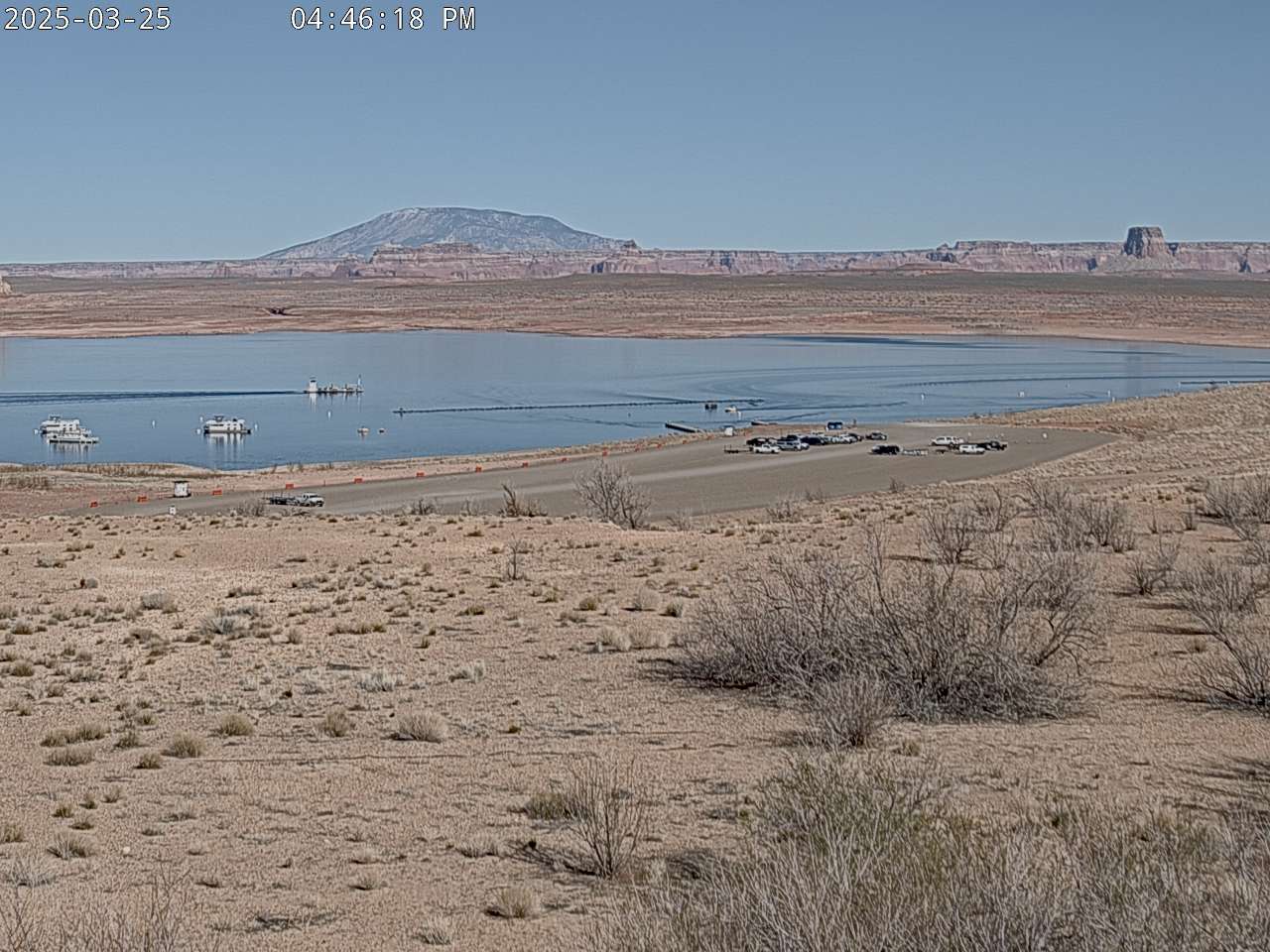
Here is a live webcam from National Park Service showing Navajo Mountain in the background (and a Glen Canyon National Recreation Area boat ramp at Lake Powell in the foreground).
Idaho Repeaters
Jumpoff
Peak - Elevation 9045 Feet (2758 meters) ASL
146.850 (-) 100.0 Hz tone
 |
Jumpoff peak may be found along the north edge of south-central Snake River basin in Southern Idaho - about 57 miles (91 km) west-northwest of Idaho Falls. This repeater (on 146.850 MHz, - offset, 100.0 Hz tone) easily covers Pocatello, Idaho Falls, and much of the rest of the southern portion of Idaho. This portion of the Intermountain Intertie could be considered to be the "Idaho Hub" as it connects to the Malad Pass site (to the south - which, in turn, is connected to the Hidden Peak hub) as well as to Mount Harrison (also to the south and west) and to the Sawtelle Peak site.
Among the many challenges associated with mountaintop sites are those of reliability and durability: Mother nature seems to throw her worst at such sites - trying constantly to break antennas and destroy radios. Jumpoff is no exception, requiring both refinement and reinforcement of the original installation. For example, the original UHF yagi link antennas were mounted near the bottom of the tower. This had two problems that, in retrospect, should have been expected:
 |
If you have ever visited a typical high mountaintop, you'll know that one simply doesn't dig a hole. This simple fact was reinforced upon installation of this link antenna mast: A jackhammer was used to put the hole into solid rock, and the heavy steel pipe had to be set into concrete (water to mix the concrete had to be brought on-site, of course) and all of these materials had to be hauled to the top of the mountain. All of this makes for a long days' work - only to return later to finish mounting the antennas, running the cables, etc. etc...
The 146.850 repeater antenna system consists of two folded dipoles, each located behind a single director (with the 1/4 wave spacing to the tower acting as a sort of reflector element. If you look carefully at the large picture showing the tower, one can just see the two antennas - one located just above the curved reflector antenna and another located just below, both oriented to direct the signal southwards. Why do this? Owing to the geography, it was decided that there was little reason to provide extensive coverage to the north as signals were blocked by the high mountains in that direction: Redirection of the signals southwards provides better coverage of and receiver sensitivity to stations in those directions than might otherwise be obtained with a typical omni (nondirectional) pattern.
As mentioned previously, this site also links the Sawtelle Peak site. Not shown in any of the pictures, this link utilizes a Telewave folded dipole (the other folded dipoles are also made by Telewave) antenna mounted on a separate pole, also away from the tower and its falling ice.
For more pictures from Jumpoff, click here.
 |
Located just south and west of West Yellowstone, Montana (but actually in Idaho... barely) the Sawtelle Peak repeater (on 145.230 MHz, - offset, 100.0 Hz tone) covers much of Yellowstone National Park and down toward the South and Southwest toward Rexbug, Idaho Falls, and much of the Upper Snake River Basin.
Sawtelle Peak (also known as "Sawtell" Peak or Mount Sawtell) is the home of one of the FAA Long-Range RADAR sites. When the 2 meter repeater was originally installed atop Sawtelle on its original frequency of 147.12, the presence of the RADAR proved to be a problem: A "buzz" would appear in the audio - not only an annoying artifact or RADAR interference, but it tended to effectively reduce the sensitivity of the repeater.
On August 18, 2000, Vance, WA7FDR (the trustee) got together with John, K7JL and they went to Sawtelle to see if they could solve this problem. Once on the site, they determined that the buzzing noise did, in fact, cover most of the 2 meter band - but there seemed to be less interference below 146 MHz.
At this point it was decided
that an "impromptu" frequency change was necessary. Dwight,
K6LOV graciously offered to bring the programmer from Idaho Falls (a 3
hour round-trip) to a meeting point somewhere closer to Sawtelle - so
while Vance went to meet Dwight, John, with the help of the
on-site FAA engineer, determined that a low 145 MHz repeater frequency
pair was the best choice.
 |
With the aid of an ARRL repeater directory and a few phone calls to the Idaho, Montana and Wyoming coordinators, it turned out that the 145.23 pair was available (a distinct advantage of being in the middle of nowhere... where there are still some pairs available.) After meeting Dwight and returning to the site, Vance reprogrammed the repeater (thank goodness that it is synthesized...) and John retuned the cavities for the new frequencies.
When all was said and done, the RADAR interference was no longer a major problem - only noticeable on weaker signals. The exact cause of the interference? It is hard to tell: The "buzz" (from the RADAR's modulation) seemed to come from everywhere on site. It is possible that some nonlinear junctions are present with resonances that happen to be in the 2 meter band. It could be radiation from some equipment (such as the power supply or pulse modulator) or even re-radiation from something else entirely. Fortunately, whatever is doing the re-radiation hasn't "drifted" down in frequency: The 145.23 pair remains relatively clear to this day.
The Sawtelle Peak repeater is almost always linked with the other repeaters in Southern Idaho - and these are usually linked into the Intermountain Intertie.
For more pictures from Sawtelle, click here.
Note:
As of 7/11/03, the 2 meter antenna was replaced, putting this repeater
back into service.
 |
This repeater operates from Mount Harrison, about 16 miles (26 km) south-Southeast of Burley, Idaho on 145.27 (- offset, 100.0 Hz tone) and covers much of southern Idaho and parts of northern Utah and northern Nevada. This repeater should not be confused with another repeater, also in the Intertie and also on 145.27 located on Scott's Hill near Brighton (at the top of Big Cottonwood Canyon, between Salt Lake and Park City, Utah.) These repeaters are far enough apart and geographically separated such that they do not interfere with each other to a significant degree. Anyway, because both of these repeaters are usually linked to the same system and carry the same audio, potential interference issues are mitigated.
The Mount Harrison site is linked to the Intertie via Jumpoff Peak and provides a relay to the War Eagle Mountain repeater that, in turn, provides connectivity into the Boise area. In looking at the map on the Intertie page, you might notice that the link to Harrison (via Jumpoff) would seem to be a roundabout way of going. While this path works quite well, having the hub repeater at Jumpoff simplifies system design and increases flexibility.
For more pictures from Harrison, click here.
 |
Located on a site approximately 11 miles (17 km) west of Malad, Idaho, the Malad site serves several functions:
For more pictures from the Malad site, click here.
Shafer Butte - Elevation Approx. 7582 Feet (2311 meters) MSL
145.130 (-) 100.0 Hz tone
This repeater operates from Shafer Butte, a prominence northeast of Boise, Idaho. This repeater provides pretty good coverage in Boise and surrounding areas.
Originally, this repeater was
on 145.230, but low-level spurious signals from a nearby site
effectively "jammed" the input frequency when it was active so it was
moved to 145.270 as a "temporary" measure. In mid September, 2018 it was moved to its current frequency of 145.130.
New pictures from the Shafer Butte site now that equipment was moved into a Forest Service building in 2025.:


Arizona Repeaters
In mid-October of 2023 three more linked repeaters from the Arizona Repeater Association (ARA)Jacob Lake - Elevation 7900 ft. (2408 meters) ASL
147.300 (+) 100.0 Hz tone
Site located south of Fredonia, Arizona. Jacob Lake site pictures are here including:


Mount Elden - Elevation 9301 ft. (2835 meters) ASL
448.875 (-) 100.0 Hz tone
Site located near Flagstaff, Arizona.
Towers Mountain - Elevation ~7600 ft. (2316 meters) ASL
449.175 (-) 100.0 Hz tone
Site located south of Prescott about 23 miles.
White Tanks - Elevation ~4100 ft. (1250 meters) ASL
442.275 (+) 100.0 Hz tone
Site located west of Phoenix about 30 miles.
Scottsdale Airpark - Elevation ~1450 ft. (442 meters) ASL
441.625 (+) 100.0 Hz tone
Site located near the Scottsdale airport.

Other pages of possible interest:
|
Occasionally, we get some pictures of and information about other repeaters affiliated in some way or another with the Intermountain Intertie. While we may not have enough information to devote an entire web page to that repeater, we feel that it may be of some general interest: After all, some of you are interested in how all of this goes together... |
Go to the Utah VHF Society Home Page
Questions, updates, or comments pertaining to this web page may be directed to: uvhfs@utahvhfs.org
This
page was last updated on 20180919


